|
#2
13th October 2016, 01:35 PM
| |||
| |||
| Re: IIT Roorkee Location Map
Don’t worry I will tell you Indian Institute of Technology Roorkee, location map and route to reach at campus. Ways to reach at Institute By Roadways Traveling from Delhi, Roorkee is located towards north approximately 170 kilometers. Take the highway NH58, and it passes through Roorkee. The city of Haridwar is located further on the same highway about 29 kilometers from Roorkee. The main bus depot of Roorkee is located on NH58. Several buses run from various cities in North India. By Airways Nearest airport to Roorkee is Dehradun's Jolly Grant airport which has Air India, Spice Jet and Jet Airways services from New Delhi. But most preferable airport nearest from Roorkee is the New Delhi International Airport which is about 180 kilometers away. By Railways Easiest way to get to Roorkee is by train. There are several trains serving Roorkee daily from various cities around. The high speed trains Shatabdi and Jan Shatabti also stop at Roorkee on their route Delhi - Dehradun. By train, it takes less than 3 hours and 30 minutes to reach Roorkee from Delhi, so it is the fastest and most economical way of travel. Incidentally, the first locomotive of India ran on rails in Roorkee in 1846, well before the first passenger rail that ran in Thane. Type of Trains Shatabdi Express (Daily) 7.00 a.m. Jan Shatabdi Express (Daily) 3.10 p.m. Okha Express 12.30 p.m. Indore- Dehradun Express 12.30 p.m. Ujjain - Dehradun 12.30 p.m. Bombay Dehradun (Daily) 7.00 a.m. Here is the location map Location Map of Indian Institute of Technology Roorkee 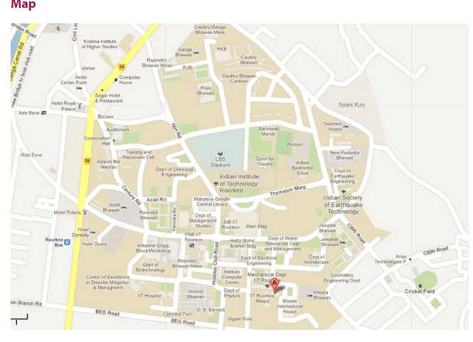 Address:- Indian Institute of Technology Roorkee Roorkee - Haridwar Highway, Roorkee, Uttarakhand 247667 Phone:- 01332 285 311 |