|
#2
13th January 2017, 05:23 PM
| |||
| |||
| Re: IIT Kharagpur Water Resources Engineering
The syllabus of Lesson 3 Remote Sensing and GIS for Water Resource Management of Module 6 Management of Water Resources under Water Resources Engineering – Civil Engineering in IIT Kharagpur is as follows: Instructional objectives: On completion of this lesson, the student shall learn about: 1. The techniques of Remote Sensing and Geographic Information System (GIS) 2. Different types of remotely sensed images 3. Application of Remote Sensing in water resources engineering 4. Application of GIS in water resources engineering 6.3.0 Introduction 6.3.1 Remote sensing through satellites 6.3.2 Interaction of electromagnetic radiation and earth 6.3.3 Interaction of electromagnetic radiation with a surface 6.3.4 Interaction of electromagnetic radiation with earth surface features 6.3.5 Spectral signature of earth features 6.3.6 Remote sensing and imaging systems 6.3.7 Spectral signatures 6.3.8 Application areas of Remote Sensing in Water Resources Engineering 6.3.9 Geographic Information System (GIS) 6.3.10 Handling of spatial and attribute data in GIS 6.3.11 Input and editing of data in GIS 6.3.12 Analysis of data in GIS 6.3.13 Data output in a GIS 6.3.14 Application areas of GIS in Water Resources Engineering  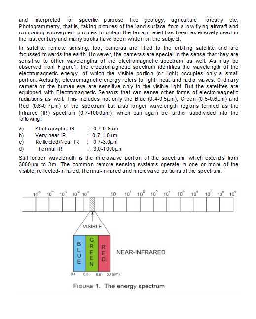 |